


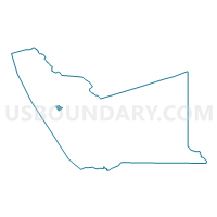
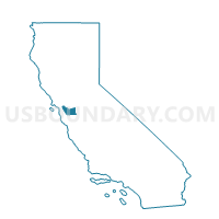
Voting District 31165, Alameda County, California
About
Outline

Summary
| Unique Area Identifier | 528928 |
| Name | Voting District 31165 |
| County | Alameda County |
| State | California |
| Area (square miles) | 0.93 |
| Land Area (square miles) | 0.93 |
| Water Area (square miles) | 0.00 |
| % of Land Area | 100.00 |
| % of Water Area | 0.00 |
| Latitude of the Internal Point | 37.68442110 |
| Longtitude of the Internal Point | -122.15375240 |
Maps

Graphs
Select a template below for downloading or customizing gragh for Voting District 31165, Alameda County, California


Neighbors
Neighoring Voting District (by Name) Neighboring Voting District on the Map
- Voting District 30920, Alameda County, CA
- Voting District 31130, Alameda County, CA
- Voting District 31150, Alameda County, CA
- Voting District 31160, Alameda County, CA
- Voting District 31170, Alameda County, CA
- Voting District 31210, Alameda County, CA
Top 10 Neighboring County Subdivision (by Population) Neighboring County Subdivision on the Map
Top 10 Neighboring Place (by Population) Neighboring Place on the Map
Top 10 Neighboring Unified School District (by Population) Neighboring Unified School District on the Map
Top 10 Neighboring State Legislative District Lower Chamber (by Population) Neighboring State Legislative District Lower Chamber on the Map
Top 10 Neighboring State Legislative District Upper Chamber (by Population) Neighboring State Legislative District Upper Chamber on the Map
Top 10 Neighboring 111th Congressional District (by Population) Neighboring 111th Congressional District on the Map
Top 10 Neighboring Census Tract (by Population) Neighboring Census Tract on the Map
- Census Tract 4333, Alameda County, CA (6,834)
- Census Tract 4334, Alameda County, CA (6,305)
- Census Tract 4336, Alameda County, CA (5,978)
- Census Tract 4358, Alameda County, CA (5,382)
- Census Tract 4359, Alameda County, CA (5,073)
- Census Tract 4335, Alameda County, CA (4,352)